Understanding your land is the first step to doing the job right. Our topography mapping services provide accurate insight into the elevation, contours, and slope of your property. Using precision equipment and skid steer technology, we can analyze and shape the terrain to match your project’s needs — whether it’s grading for drainage, building pads, or landscape design.
2D topography mapping creates a flat, aerial-style map that shows the elevation, layout, and key features of a property or job site.
3D Documents
Fully detailed digital model
Take your project planning to the next level with our 3D topography mapping services. Using advanced scanning and GPS technology, we create a high-accuracy 3D model of your land — showing every contour, slope, and elevation in detail. Perfect for grading, excavation, and site design, this service ensures your project starts with precision and confidence.
HOA Planning
Community-focused results
We partner with Homeowners Associations (HOAs) to help manage and maintain shared community spaces with precision and care. From topography mapping and grading to landscaping, drainage solutions, and erosion control, our skid steer services keep neighborhoods safe, functional, and visually appealing.
eco options
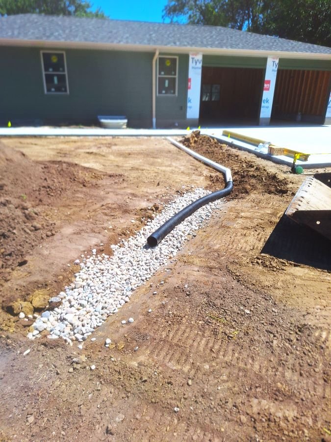
BioSwale
This is a modern option for water run-off management called a bioswale. It’s a subsurface shallow trench or pit filled with drain rock. The black pipe is a leach pipe designed to drain minimal amounts of water. It is connected to a pop-up drain located centrally in the yard designed to release moderate and high amounts of storm run-off. This subsurface basin is topped with garden cloth to minimize silting in and buried 4-6 inches in top soil. This design is intended to have a tree or multiple decorative trees planted near the bioswale so their roots can take advantage of this method of water re-use.
There are many methods of water re-use and types of bioswales. All of these modern methods can be applied to make your haven as eco-friendly as possible.